Art and the Pearl River Delta Environment
Walter E. Parham, Ph.D.
Federation of American Scientists
Washington D.C.
Presented at the International Symposium on Environment and Society
in Chinese History
Center for Chinese Social History
Nankai University, Tianjin, PRC
August 17–19, 2005
Abstract:
History tells us that South China and the Pearl River Delta region in particular began to suffer environmental damage about 1000 years ago when large numbers of people migrated from north to south. The forest vegetation was removed for a variety of reasons: to provide firewood, building materials, and to make charcoal; to clear land for farming and settlements; to provide safety from fire, wild animals, snakes, and bandits. Much of the land in the Pearl River Delta region is still in a damaged and degraded state.
Western and Chinese artists who frequented the Pearl River Delta region recorded the damage in paintings and drawings. In addition, land and vegetation damage is shown in some early photographs taken in China.
Until about 1750, Chinese art lacked perspective. The local Chinese artists learned to draw using the perspective technique from foreign artists and then began to incorporate the technique in their works. Even though the Western and Chinese artists probably were not trained in geology/geomorphology, they demonstrated keen observations in their art works related to the nature of the land surface. The Western and Chinese artists show that the land was largely deforested and badly eroded 200 years ago. Historical art depicting the Pearl River Delta region can be used in geological and geomorphological applications, such as to determine the type of local bedrock, determine the intensity of rock weathering, and to assess the status of soil erosion.
This study finds that
- much of the artwork produced by Western and Chinese artists about150-200 years ago shows that they accurately represented the Chinese landscape,
- the land and the wildlife habitats were already severely damaged in the 1700s and 1800s,
- geological information inadvertently recorded in historic art matches current geological knowledge.
Considerable agreement exists among historical art works produced by different artists over 200 years regarding the condition of the environment of the Pearl River Delta region. It is unlikely that there were extensive, undamaged wildlife habitats that remained in this region at this time. Using art to determine the condition of the land and vegetation in the Pearl River Delta region 200 years ago may provide some difficulties. However, it may be even more difficult to determine the condition of the Pearl River Delta region in just 15 years from now when an estimated additional 70 million people move into the area.
Introduction:
History tells us that South China and the Pearl River Delta region (Fig. 1) in particular began to suffer environmental damage about 1000 years ago when large numbers of people migrated from north to south (Marks, 1998; Parham et al., 1993). As agriculture expanded, the loss of vegetation caused destruction of wildlife habitats for large animals like elephants, tigers, deer, and buffalo.
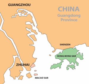
Figure 1: Map of the Pearl River Delta Region
The forest vegetation was removed for a variety of reasons: to provide firewood, building materials, and to make charcoal; to clear land for farming and settlements; to provide safety from fire, wild animals, snakes, and bandits (Grant, 1960; Marks, 1998; and Parham et al., 1993). Elephants disappeared from the region in about 1400 primarily because of forest destruction (Marks, 1998; Elvin, 2004). Tigers persisted until the early 19th century when their forest habitat became highly fragmented (Marks, 1998) and the number of tigers has continued to decline since.
The region is composed largely of granite and volcanic rocks, chemical weathering reaches depths of 60 to 80 meters, soil fertility is poor, and fires and landslides are common. Once deforested, the land eroded easily.
Much of the land in the Pearl River Delta region is still in a damaged and degraded state. It is likely that much of the land’s appearance is a result of past, damaging land-use practices. Biological and physical scientists who study this region recognize clues that support the story of past, widespread, damage to the land, vegetation, and wildlife. Nevertheless, we can only imagine how the appearance of the land changed as human activities altered the land and its vegetation. It is evident from recent studies (Parham et al., 1993) that land abuse continued to have additional adverse affects over the last 50 years. World War II, China’s Great Leap Forward and its Cultural Revolution, coupled with the region’s booming economic development, certainly are recognized as contributing factors to further environmental damage. Nationwide, China’s natural ecosystems are degrading, habitat loss has accelerated, and the number of native species is decreasing (SEPA, 2002).
Western and Chinese artists who frequented the Pearl River Delta region have recorded the damage in numerous paintings and drawings. These works of art are one way to look back into the past to examine how the landscape appeared 200 years ago. Other researchers have tried similar techniques to link art and the environment. For example, one researcher, who was interested in whether or not cloud cover increased during the Little Ice Age during 1450 to 1850, examined thousands of art works in European and American museums that were painted during that period (Fagan, 2000). He recorded the type and amount of cloud cover in each painting and showed statistically that cloud cover was significantly more common over Europe during the Little Ice Age His results show how art and environmental change can be linked effectively.
Environmental damage is also documented in some of the earliest photographs taken in China. These only date back to 1844; a few daguerreotype photographs of Hong Kong (Hacker, 1997) show some environmental damage in the 1860s. Many early photographs were taken in the Treaty Ports and not the countryside One drawback is that finding non-inventoried China photographs today requires an unreasonable amount of time for the researcher (Thiriez, 2000).
Background:
While visiting local Hong Kong art museums, I saw paintings of the Pearl River Delta region by Western and Chinese artists. Many showed that the artists paid careful attention to land-form detail. It seemed possible to extend our visual knowledge of the Delta region’s land surface back in time using these early art works. The goal of this study is to answer these questions:
1. Did the Western and Chinese artists accurately represent the Chinese landscape in the 1700s and 1800s?
2. What does art tell us about the past condition of the land and wildlife habitats in the Pearl River Delta region?
3. What can we learn from historic art about the region’s geology and geomorphology?
Source material:
A recent publication (Sargent, and Palmer, 1996), which combines much of the Asian Export Art from the Hong Kong Museum of Art (www.lcsd.gov.hk/CE/Museum/Arts/) and that of the Peabody Essex Museum (www.pem.org) in Salem, Massachusetts, contains a number of examples in which geological and geomorphological features are well depicted, and where the general state of the land is recorded. The Wason Collection of East Asia at Cornell University Library (www.explore.cornell.edu) also has useful images. In addition, Asian Export Art dealers have Internet sites that show relevant Chinese and Western art.
Some of the first European artists who visited the Pearl River Delta on trading ships and naval vessels sketched and painted the local landscapes. These artists, in the process, passed some of their skills on to local Chinese artists who later incorporated the new skills in subsequent art work. The blending of Chinese art techniques with those from the West developed into Asian Export Art, an important new business at the time (Sargent, and Palmer, 1996). Many of the artists noted as “Anonymous” in the images of this paper probably were local Chinese artists.
Until about 1750, Chinese art lacked perspective, a technique of geometry that local artists learned from foreign artists, and began to incorporate in their works (Sargent, and Palmer, 1966). Sargent and Palmer (1996) point out also that “truth” and “accuracy” in many Chinese paintings from the Pearl River Delta region became established about 1788. Interestingly, Elvin (2004) notes that Chinese maps also improved their precision by 1850.
Method:
I examined a large part of the 1200 image historical collection of the Hong Kong Museum of Art (HKMA) available to the public on the web site. Some of their referenced collection are in this paper. In addition, I searched the literature for collections of old-photographs from Hong Kong and South China without a great deal of success. Numerous collections of Asian art also exist in American universities and museums, but only part of their collections are available today on the Internet.
Environmental assessment of historical art:
Past condition of the land and wildlife habitats
Dinghushan (Fig. 2) is a Man and the Biosphere Reserve situated 86 km west of Guangzhou (Kong et al., 1993).
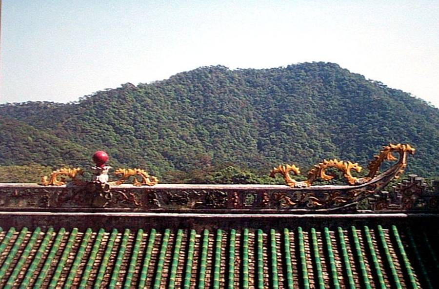
Figure 2: The moist, tropical, broad-leaf forest at Dinghushan is at least 400 years old, and once provided habitat for the South China Tiger (Photo by W. Parham, 2003).
This 900-hectare remnant of original tropical, evergreen, broad-leaf forest is at least 400 years old and is all that remains today of a forest that originally covered much of Guangdong Province and adjacent areas. The forest was the home of the elephant until 1400, and the South China tiger (Figure 3, below)
 until the early 19th century. This tiger may have become extinct in the wild as of 2004 (Tilson, 2004) as habitat and prey decreased, though about 50 remain in zoos. The tiger population has decreased from about 4000 in 1949 (Koehler, 1991).
Now, compare the picture of Dinghushan to South China’s Pearl River Delta region of about 200 years ago. The sketch (Fig. 4) by a HMS Lion crew member shows that grasslands prevailed, forest cover had been destroyed along the east side of the Pearl River near its mouth, and that landslides were clearly evident.

Figure 4: Deforested land, and landslides near the mouth of the Pearl River in 1793 (with permission of Cornell University Library, Wason Collection of East Asia).
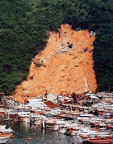
Figure 5: Landslides during the rainy season are common. Click on photo to see vehicles trapped by slide, (Hong Kong Geological Survey Collection).
Lan Tau Island (Fig. 6), about 20 km further south, still exhibits an extensive grass-land cover and an absence of its original forest. Fires commonly sweep across such grasslands generally in the fall requiring as much as five to ten years for the vegetation to grow back to its pre-fire condition. These fires, caused by man, continue to threaten wildlife habitats in the region today.

Figure 6: Lan Tau Island, Hong Kong, once forested, is now covered with grasslands (Photo by W. Parham, 1967).
About 20 km east of Lan Tau Island in eastern Hong Kong, Murdoch Bruce’s painting (Fig. 7) shows extensive grasslands as well as deep erosion scars.

Figure 7: Eroded and deforested Hong Kong mainland, 1846 (Hong Kong Museum of Art Collection)
Two paintings of the north side of Hong Kong Island, probably by different Chinese artists (Fig. 8) and (Fig. 9), are similar in showing the deeply eroded mountain side, the general lack of forest cover, and the presence of some grass cover.

Figure 8: Hong Kong Island, 1847 (Hong Kong Museum of Art Collection).

Figure 9: Deeply eroded Hong Kong Island, 1855-60 (Hong Kong Museum of Art Collection)
Opposite Hong Kong Island on the mainland, John Collins shows Kowloon, where Fort Victoria once existed. The land is barren and treeless (Fig. 10).
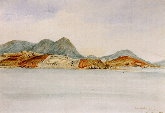
Figure 10: Barren Kowloon, Hong Kong, 1841 (Hong Kong Museum of Art Collection).
The view from western Hong Kong Island with its outlying islands (Fig. 11) painted by Edward Hildebrandt, also shows a badly damaged landscape with few trees .
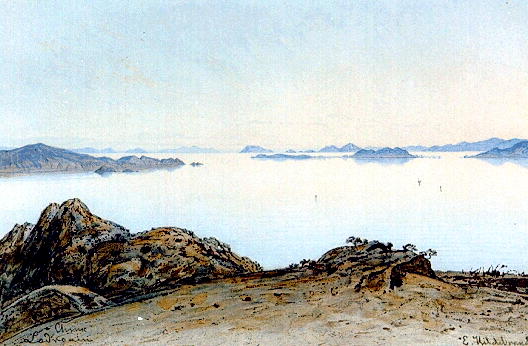
Figure 11: Deforested western Hong Kong and adjacent islands, 1860s (Hong Kong Museum of Art Collection).
Closer views of the land show severe damage. For example, William Lodder shows that tombs (Fig. 12), which people dug by hand into Hong Kong’s deeply weathered, granite hillsides, are surrounded by a scalped or denuded landscape with vegetation consisting of no more than a few bushes growing in small depressions. Such sites composed of weathered granite are subject to severe erosion during the rainy season and it is difficult for vegetation to reestablish itself.

Figure 12: Denuded landscape, Hong Kong, 1833-57. Tombs dug into deeply weathered granite (Hong Kong Museum of Art Collection)
Similarly, Auguste Borget shows the north side of Hong Kong Island where either soil erosion has exposed the tree’s root system or the roots shown are natural for the banyan tree (Fig. 13). His painting shows that all of the surrounding soil surface also is barren.

Figure 13: Eroded soil showing tree roots and barren land, 1838 (Hong Kong Museum of Art Collection).
The eroded south side of Hong Kong island (Fig. 14),shown in Edward Hildebrandt’s painting, is deforested and deeply eroded exposing large, granite core-stones. Small patches of grass cover are scattered over the eroded weathered granite.

Figure 14: Eroded south side of Hong Kong Island, 1860s (Hong Kong Museum of Art Collection)
In another view of the island’s south side (Fig. 15), William Lodder shows some orderly replanting of trees near sea level that may be a plantation, but high on the hills, a barren landscape prevails.

Figure 15: South side of Hong Kong Island’s barren hills, 1833-57 (Hong Kong Museum of Art Collection).
Geology and geomorphology
Historical art depicting the Pearl River Delta region provides several geological and geomorphological applications such as: determining the type of local bedrock, intensity of rock weathering, and the status of soil erosion. Certain land forms, such as inselbergs, core stones, and beng-gang erosion, can be identified readily from the art. These features help to identify the composition of the underlying bedrock. The features that the artists depicted pre-date the first rudimentary geological description of Hong Kong in 1865 and Hong Kong Island’s first geological map in 1880 (Davis, 1953). Nevertheless, it is clear that the art in a large part is an accurate representation of what modern geological maps show.
Pearl River Inselberg island
Situated in the Pearl River near Humen, is a rounded, dome-shaped island that geologists refer to as an inselberg. This particular (granite or conglomerate) inselberg is formed from concentric layers of rock displaying an onion-like structure (Fig. 16).

Figure 16: Generalized layered-model of an inselberg island (Photo by W. Parham)
As rock layers exfoliate, or fall away, during the process of weathering, the island continues to maintain its smooth, dome-like form (Fairbridge, 1968).
The inselberg island is easily distinguished (Fig. 17) from the many other islands that are irregular, eroded rock remnants lacking this structure.
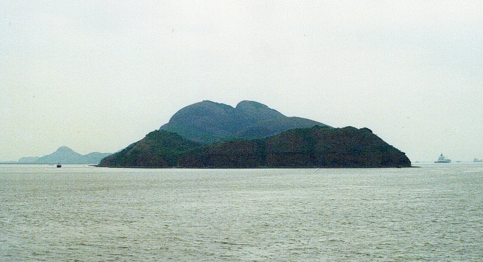
Figure 17: Inselberg island (background) near Humen, 1994 (Photo by W. Parham).
The inselberg island is situated where the Pearl River narrows rapidly as one travels from the South China Sea to Canton (Guangzhou), an area referred to at Bocca Tigris, the “tiger’s mouth”. The Bocca Tigris was the historical site of several old Chinese forts that were important during the Opium Wars, and was apparently a favorite place for artists to draw or paint island pictures, the inselberg island in particular. The following seven art works cover a 53-year time span.
John Meares’ sketch of the inselberg island (Fig. 18) shows some vertical exaggeration but the island still is recognizable.
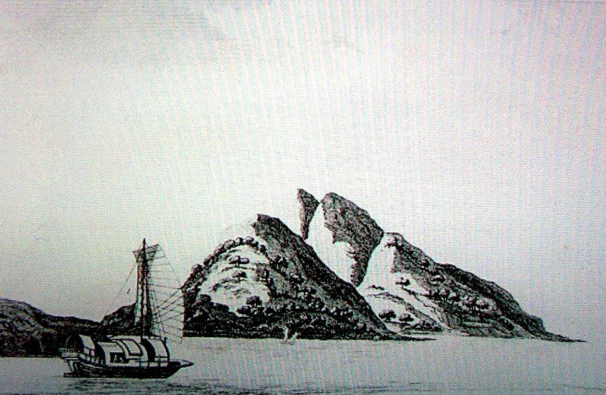
Figure 18: Pearl River inselberg island, 1794 (Hong Kong Museum of Art Collection).
The artist from the HMS Lion also exaggerated the island’s height somewhat but he caught more of the inselberg’s dome-like form (Fig. 19) than John Meares.

Figure 19: Pearl River inselberg island, 1793-94 (Permission of Cornell University Library, Wason Collection of East Asia).
A somewhat later painting of the island (lower left) by William Alexander (Fig. 20) clearly is recognizable by its characteristic, rounded form.

Figure 20: Pearl River inselberg island, 1796 (Hong Kong Museum of Art Collection).
A later artist, probably Chinese, drew the island’s shape in greater detail (Fig. 21).
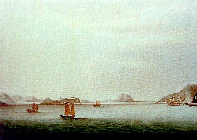
Figure 21: Pearl River inselberg island in early 1800s (Hong Kong Museum of Art Collection).
Another anonymous artist, also probably Chinese, produced an image of the island from a long distance but its rounded shape is recognizable (Fig. 22).

Figure 22: Pearl River inselberg island, 1800s (Hong Kong Museum of Art Collection).
William Lodder accentuated the rock separation in the island’s form as is evident in some other of the island’s drawings but he did not emphasize the dome form as much as others (Fig. 23).

Figure 23: Pearl River inselberg island, 1833-57 (Hong Kong Museum of Art Collection).
Lt. Martin showed the rock separation too, but gave the island sharper peaks (Fig. 24).

Figure 24: Pearl River inselberg island, 1847 (Hong Kong Museum of Art Collection).
J.W. Johnson painted a small island with a prominent vertical rock at its center and surrounded by what appear to be core stones (Fig. 25).

Figure 25: Granite tor, Hong Kong, 1840s (Hong Kong Museum of Art Collection).
Though not an inselberg, this geological feature, called a tor, is not unusual in areas where core-stone formation is common.
The unusual shape of the inselberg island obviously caught the attention of the various artists spanning the fifty-three years of art cited above. In many cases it was the artist’s focal point. All of the inselberg-island images are recognizable and show common features. Other than some vertical exaggeration in a few works, the likenesses are reasonably similar. The artists in essence produced images of what they saw rather than what they imagined. Though they probably lacked geological training, the images they produced are useful to the geologist and geomorphologist in reconstructing the landscapes history.
Core stones
Core-stone formation is common where granite is subjected to chemical weathering in the wet tropics. Weathering along joint planes in granite leaves the adjacent granite adjacent to the joint unaltered. Once the vegetative cover is removed, erosion carries away the weathered material from the joint planes which form assemblages of fresh core stones on the land’s surface resembling a pile of sugar cubes (Fig. 26).
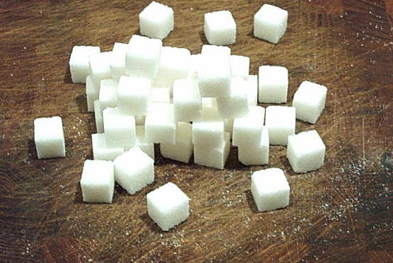
Figure 26: Generalized model of core-stone formation (Photo by W. Parham).
During periods of heavy rains, the core stones, some as large as automobiles, slide or roll down hills threatening people and man-made structures.
Core stones are common in the Pearl River Delta region. A dense collection covers part of Tai A Chau, a small granite island west of Hong Kong (Fig. 27).

Figure 27: Core stones on Tai A Chau, Hong Kong, 1998 (Hong Kong Geological Survey Collection).
Core stones appear in many historical drawings and paintings from the region. A sketch of a section of a village shoreline (Fig. 28)by William Lodder shows an assemblage of large core stones along the shore as well as some smaller ones on the barren land on the hills above.

Figure 28: Barren land and core stones, Hong Kong, 1833-57 (Hong Kong Museum of Art Collection).
One of the first daguerreotype photographs taken in Hong Kong (Fig. 29) shows the entire hillside behind a temple covered with core stones of various sizes. Modern geological maps indicate that this hill, in fact, is composed of granite (Allen, and Stephens, 1971).
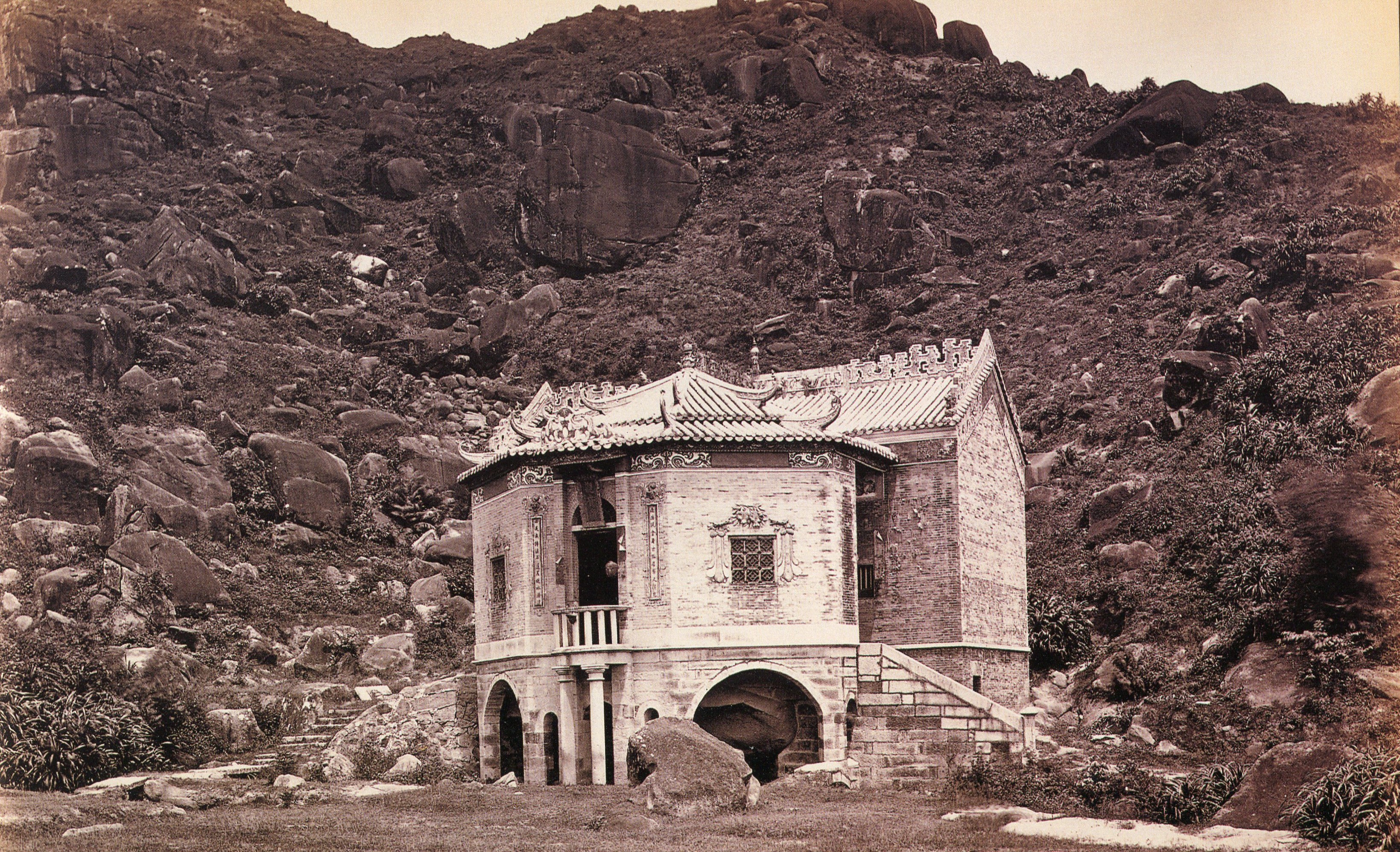
Figure 29: Daguerreotype of Hong Kong core stones, 1860s (Wattis Fine Arts Collection, Hong Kong).
The Chinese artist Sunqua may have painted this view of Hong Kong (Fig. 30). The left half of the painting of Hong Kong Island shows a land surface covered with numerous core stones. The right half, however, shows very few. Geological maps (Allen, and Stephens, 1971) show that the left half of the island is composed of granite as is the lower right-hand part, and that the upper right-half is composed of volcanic rocks. Core stones form more readily in areas where granite is the bedrock .

Figure 30: Numerous core stones on granite area of Hong Kong Island, 1854 (Hong Kong Museum of Art Collection).
Beng-gang gully erosion
Beng-gang is the Chinese name for the horse-shoe shaped, gully erosion features common in deeply-weathered granite of South China. Typically, the gully has a steep back wall and a narrow outlet like the one in Zhuhai (Fig. 31). Beng-gang gully erosion can develop rapidly on hill slopes during heavy rains where vegetation is sparse or absent. Chinese researchers (in Parham et al., 1993) found that a combination of biological and engineering techniques works effectively to halt the beng-gang erosion process.
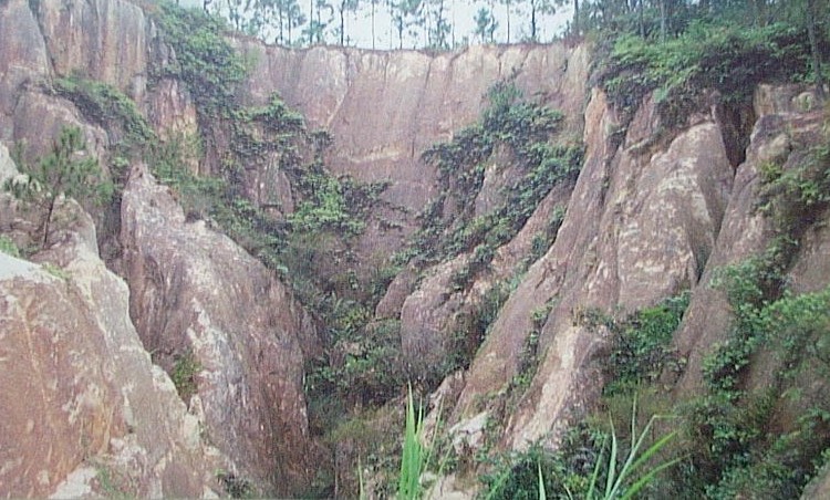
Figure 31: Beng-gang gulley erosion in weathered granite, Zhuhai, PRC, 2003 (Photo by W. Parham).
Murdoch Bruce’s Hong Kong painting (Fig. 32) shows well developed beng-gang gully erosion in grass-covered, weathered-granite hills in the background .

Figure 32: Beng-gang erosion and core stones, Hong Kong, 1846 (Hong Kong Museum of Art Collection).
Similarly, core stones are evident on the hilltop to the right. Lt. Martin, a navy artist, shows advanced beng-gang erosion in grass-covered hills at Annunghoi inside the walls of a Chinese fort at Bocca Tigris (Fig. 33).

Figure 33: Beng-gang gulley erosion, Annunghoi, Pearl River, 1847 (Hong Kong Museum of Art Collection).
Lt. Martin produced (Fig. 34) a second painting that year of the same site but the beng-gang feature lacks as much definition.

Figure 34: Beng-gang gulley erosion, Annunghoi, Pearl River, 1847 (Hong Kong Museum of Art Collection).
William Lodder’s sketch (Fig. 35) and his painting (Fig. 36) were drawn from two overlapping sea views of the land. The sketch shows advanced beng-gang erosion cutting through a low hill on the left. His painting shows the same erosion site directly behind the mast of the ship. Both images show badly eroded hills, some core stones, and a devastated zone above the painting’s shoreline.

Figure 35: Beng-gang gulley erosion, Hong Kong, 1833-57 (Hong Kong Museum of Art Collection).
Figure 36: Beng-gang gulley erosion, Hong Kong, 1833-57 (Hong Kong Museum of Art Collection).
William Lodder also sketched treeless Green Island (Fig. 37) where evidence of beng-gang erosion existed. Geologic maps verify that the island is at least one-half granite (Allen, and Stephens, 1971).

Figure 37: Beng-gang gulley erosion, Hong Kong, 1857 (Hong Kong Museum of Art Collection).
Another William Lodder sketch shows a sampan at West Point, Hong Kong (Fig. 38). The sketch exhibits some vertical exaggeration but beng-gang erosion and core stones are evident at this granite site.
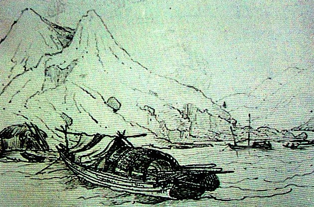
Figure 38: Beng-gang gully erosion and core stones, West Point, Hong Kong, 1857 (Hong Kong Museum of Art Collection).
Conclusions:
- Much of the artwork produced by Western and Chinese artists about 150-200 years ago shows that they accurately represented the Chinese landscape.
- The land and the wildlife habitats were already severely damaged in the 1700s and 1800s.
- Geological information inadvertently recorded in historic art matches current geological knowledge.
Considerable agreement exists among historical art works produced by different artists over 200 years regarding the condition of the environment of the Pearl River Delta region. The artists painted what they saw even though they probably knew little of the scientific significance of the land features they recorded.
The Western and Chinese artists show that the land was largely deforested and badly eroded 200 years ago. The condition of land then and now appears to be similar even though efforts have been made in some areas in recent years to restore tree cover.
It is unlikely that there were extensive, undamaged wildlife habitats that remained in this region 200 years ago. Habitat destruction in the Pearl River Delta region depicted in the cited historical art works, combined with continued hunting and trapping of native prey species, may already have led to the extinction of the South China tiger. The estimated tiger population in the wild was 4000 in 1949, 150-200 in 1981-82, and 30-50 in 1991, with about 50 more housed in zoos (Koehler, 1991). Recent, broad, field surveys of South China areas where the tiger might still exist produced no sightings (Tilson, 2004).
Even though the artists probably were not trained in geology, they demonstrated keen observations in their art works as to the nature of the land surface. Early geologists who visited the Pearl River Delta region could have, or perhaps even did benefit from examining the local art of that time. Their assessment of the correctness of the artists’ observations regarding the state of the land could have provided useful information at that time about the bedrock geology, and the weathering and erosion history of the region. The presence of core stones, core-stone distributions, wide-spread beng-gang gully erosion, the presence of tombs dug by hand in weathered granite, prominent exposure of tree roots, for example, are all important clues in reconstructing the region’s geological history and geological processes affecting the region.
The use of art to look back 200 years to determine the condition of the land in the Pearl River Delta may seem somewhat difficult. However, determining what the condition of the delta region’s land will look like in just the next 15 or 20 years may be equally difficult. Today, the Pearl River Delta economic zone accounts for about one-third of China’s total trade and land development is taking place here very rapidly. Perhaps today’s artists will continue to record the rapidly moving land changes for us, and that within their art work images, they will record additional important information useful to ecologists and geologists.
Acknowledgements:
The author wishes to thank the following organizations for their permission to use their art and photographic collections:
The Hong Kong Museum of Art, Historical Collection
The Hong Kong Geological Survey
The Wason Collection on East Asia, Cornell University Library
Wattis Fine Art, Hong Kong
The Tiger Foundation, Canada
References cited:
Allen, P.M., and Stephens, E.A., 1971, Report on the geological survey of Hong Kong, J.R. Lee, Government Printer at the Government Press, Hong Kong, 107 p.
Davis, S.G., 1953, The geology of Hong Kong, The Government Printer, Hong Kong, 210 p.
Elvin, M., 2004, The retreat of the elephants, Yale Univ. Press, New Haven, CT, 564 p.
Fagan, B., 2000, The Little Ice Age, Basic Books, New York, 246 p.
Fairbridge, R.W., 1968, The encyclopedia of geomorphology, Reinhold Book Corp., New York, 1295 p.
Grant, C.J., 1960, Soils and agriculture of Hong Kong, Government Printer at the Government Press, Hong Kong, 154 p.
Hacker, A., 1997, Hong Kong: A rare photographic record of the 1860s, Printer’s Circle Ltd., Hong Kong, 80 p.
Koehler, G., 1991, Survey of remaining wild population of South China tiger, Save China’s Tigers website, http://www.savechinstigers.net, WWF Project 4512/China Final Project Report, 9 p.
Kong et al., 1993, Dinghushan Biosphere Reserve: ecological research history and perspective, Science Press, Beijing, 38 p.
Marks, R. B., 1998, Tigers, rice, silk, and silt, Cambridge University Press, New York, 383 p.
Parham, W., Durana, P., and Hess, A., 1993, Improving degraded lands: Promising experiences from South China, Bishop Museum Bull. 3 in Botany, Bishop Museum Press, Honolulu, Hawaii, 243 p.
Sargent, W.R., and Palmer, M., Production Team Leaders, 1996, Views of the Pearl River Delta: Macau, Canton, and Hong Kong, Urban Council, Hong Kong, and the Peabody Essex Museum, Salem, MA, Fairmount Printing Factory Ltd., Hong Kong, , 239 p.
SEPA, State Environmental Protection Administration, 2002 Report on the state of the environment in China, SEPA, Beijing, 35 p.
Thiriez, Regine, 2000, Library collections and early photography in China; Internat. Assoc. Orientalist Librarians IAOL, Bull. No. 44, 3 p.
Tilson, R., et al., 2004, Dramatic decline of wild South China tigers Panthera tigris amoyensis: field survey of priority tiger reserves, Oryx, v. 38, p. 40-47
Direct mailing address:
Walter E. Parham, Ph.D.
Federation of American Scientists
1838 Horseback Trail
Vienna, Virginia 22182
USA
e-mail: parham305@aol.com
tel. (703) 281-1496
fax (703) 281-1457

Leave a comment